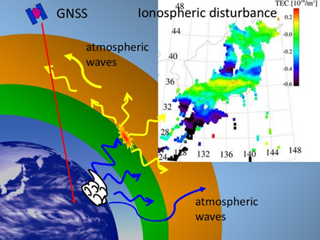
At the boundary between the Earth’s atmosphere and space, part of the atmosphere is ionized by solar radiation, forming the ionosphere. GNSS signals that we use for positioning are transmitted from satellites, propagate through the ionosphere, and are then received on the ground. As a result, GNSS signals are affected by the ionosphere, causing positioning errors. Conversely, these ionospheric effects on GNSS signals allow us to estimate the total electron content (TEC), which is an integration of the electron density along the radio wave propagation path. TEC is useful for ionospheric research.
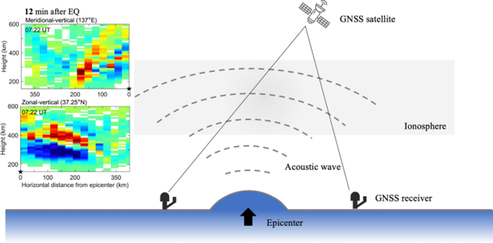
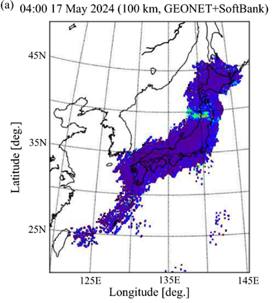
The ionosphere varies significantly by solar activity and by Earth’s lower atmosphere (Figure 1). We have utilized observation data from an ultra-dense GNSS receiver network installed across Japan to develop a high-resolution three-dimensional ionospheric tomography technique. This approach enables us to reconstruct the three-dimensional structure of ionospheric electron density variations with much higher spatial and temporal resolution than previously possible. Using this method, we can analyze in detail the generation and evolution of wave-like structures propagating in the ionosphere. For example, following the January 2024 Noto Peninsula earthquake, we captured clear evidence that acoustic waves generated by the earthquake propagated upward and reached the ionosphere, inducing electron density perturbation (Figure 2). In addition, during the severe geomagnetic storm in May 2024, we demonstrated that equatorial ionospheric disturbances known as plasma bubbles, which are localized depletions in electron density, extended as far as Japan, and we visualized their three-dimensional structure.
Furthermore, we have investigated sporadic E (Es) layer, which is a thin layer of enhanced electron density that sporadically appears near an altitude of about 100 km. We successfully disclosed their fine and complex horizontal structures at high resolution and clarified their temporal evolution from formation to decay (Figure 3).
These research achievements deepen our understanding of the coupling between the Earth and space, and are expected to contribute to forecasting of ionospheric phenomena that affect satellite communications and GNSS positioning.
References:
Fu, W., Otsuka, Y. and Ssessanga, N., High-resolution 3-D imaging of electron density perturbations using ultra-dense GNSS observation networks in Japan: an example of medium-scale traveling ionospheric disturbances. Earth Planets Space 76, 102, https://doi.org/10.1186/s40623-024-02051-2, 2024.
Fu, W., Otsuka, Y., Ssessanga, N., Shinbori, A., Sori, T., Nishioka, M., and Perwitasari, S., Unveiling the vertical ionospheric responses following the 2024 Noto Peninsula Earthquake with an ultra-dense GNSS network. Earth Planets Space 77, 77, https://doi.org/10.1186/s40623-025-02211-y, 2025.
Fu, W., Otsuka, Y., Hocke, K., Ma, G., Nishioka, M., and Jin, H., Identifying medium-scale traveling ionospheric disturbances driven by atmospheric gravity waves over Japan at sunrise and sunset terminators using high-resolution 3-D GNSS tomography. GPS Solut 29, 119, https://doi.org/10.1007/s10291-025-01875-z, 2025.
Saito, S., Yoshihara, T. and Hosokawa, K., Study of fine spatial structures of the daytime sporadic E layer and its temporal evolution by using an ultra-dense GNSS receiver network. Earth Planets Space 77, 199, https://doi.org/10.1186/s40623-025-02332-4, 2025.