March 22, 2024
Consortium to utilize the SoftBank original reference sites for Earth and Space Science
SoftBank Corp.
ALES Corp.
Graduate School of Science, Tohoku University
Disaster Prevention Research Institute, Kyoto University
SoftBank Corp. (hereinafter “SoftBank”); ALES Corp. (hereinafter “ALES”), a SoftBank subsidiary engaged in the generation and distribution of positioning correction information; the Graduate School of Science, Tohoku University; the Disaster Prevention Research Institute, Kyoto University; and the Consortium to utilize the SoftBank original reference sites for Earth and Space Science (hereinafter “the Consortium”)*1 have been continuing investigations and analyses of crustal deformation related to the 2024 Noto Peninsula Earthquake. The Consortium has also been cooperating in a wide range of research and investigation activities, including reporting its analyses to the Earthquake Research Committee of the Headquarters for Earthquake Research Promotion of the Japanese government, the Coordinating Committee for Earthquake Prediction, and relevant academic societies in Japan and abroad.※2
Using integrated analyses of data from the Noto Peninsula region among SoftBank’s high-density GNSS※3 observation network comprising more than 3,300 sites nationwide (hereinafter “SoftBank original reference sites”), the Consortium estimated coseismic horizontal and vertical displacements caused by the 2024 Noto Peninsula Earthquake, as well as the corresponding slip distribution on the fault plane. In addition, it analyzed detailed spatial distributions of crustal deformation, including uplift associated with seismic activity that has continued in the Noto Peninsula since 2020. These results have been reported to bodies such as the government’s Earthquake Research Committee※4 and are being utilized in assessments of seismic activity following the 2024 Noto Peninsula Earthquake as well as the ongoing seismicity preceding the event.
Conventionally, evaluations of earthquakes have primarily relied on GEONET, operated by the Geospatial Information Authority of Japan, and GNSS observation stations installed by universities and other research institutions. By incorporating data acquired from SoftBank original reference sites in addition to these conventional observation stations, the present analyses were able to depict crustal deformation in greater detail. This demonstrates the high spatial density and utility of data obtained from SoftBank original reference sites.
SoftBank and ALES will continue to support the Consortium’s activities, contributing not only to earthquake-related studies but also to research in other Earth science fields, including volcanoes, the troposphere, and the ionosphere. Through improved understanding of various phenomena, they aim to contribute to disaster prevention and mitigation, including enabling high-precision prediction of natural disasters.
※1 The Consortium comprises 28 departments from 21 domestic research institutions and three private companies. For details, please visit: https://csess.jp/
※2 A list of the Consortium’s research outputs is available at: https://csess.jp/research_results/
※3 GNSS (Global Navigation Satellite System) is a collective term for satellite positioning systems, such as the U.S. GPS, that determine receiver positions using radio signals transmitted from orbiting satellites. The Japanese government promotes the use of its domestic QZSS (Quasi-Zenith Satellite System), “Michibiki.” For receivers fixed to the ground, repeated measurements over time enable three-dimensional characterization of crustal deformation that occurs between observations.
※4 Evaluation materials from the Earthquake Research Committee of the Headquarters for Earthquake Research Promotion are available at: https://www.jishin.go.jp/evaluation/seismicity_monthly/
- Evaluation of seismic activity in the Noto region of Ishikawa Prefecture (published July 11, 2022)
- Evaluation of seismic activity in the Noto region of Ishikawa Prefecture (published June 9, 2023)
- Evaluation of the 2024 Noto Peninsula Earthquake (published January 15, 2024)
- Evaluation of the 2024 Noto Peninsula Earthquake (published February 9, 2024)
■Data Outcomes from Crustal Deformation Analyses (Excerpt)
- The crustal deformation and earthquake swarm that began around December 2020 in the northeastern Noto Peninsula are considered to have been caused by the ascent of fluids from depth and the associated aseismic slip. These processes promoted slip on active faults along the northern coast of the Noto Peninsula, where stress had been accumulating, ultimately leading to the 2024 Noto Peninsula Earthquake (magnitude 7.6).
- Integrated analyses using GNSS revealed that the 2024 Noto Peninsula Earthquake produced crustal deformation exceeding 2 m of westward horizontal displacement and more than 1.9 m of uplift at locations in the northern Noto Peninsula where the largest changes were observed.
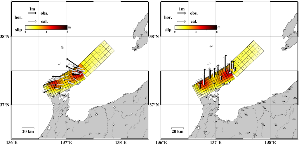
- From the horizontal and vertical displacement fields obtained through the integrated analysis, the causative fault slip distribution was estimated, revealing the presence of two major slip regions located to the east and west of the Noto Peninsula.※
※ These results are preliminary and may be subject to change as further analyses are conducted. - Following the occurrence of the 2024 Noto Peninsula Earthquake, crustal deformation has continued while gradually decelerating. Although the spatial pattern of deformation after the earthquake resembles that at the time of the event, distinct features have also been observed, such as subsidence of up to 5 cm across much of the northern Noto Peninsula during the first month after the earthquake.
- Crustal deformation caused by shallow sources at depths shallower than approximately 20 km, as observed in the seismic activity in the Noto Peninsula, tends to be localized around the source region and therefore requires observations in close proximity to the source. Consequently, integrated GNSS analyses using data from dense observation networks, such as SoftBank original reference sites, have been shown to be particularly effective for monitoring crustal deformation associated with shallow deformation sources.
■Roles of Each Organization in the Activities of the Consortium (Particularly in the Evaluation of the 2024 Noto Peninsula Earthquake)
SoftBank / ALES
Among the SoftBank original reference sites in the Noto Peninsula region, ALES converted observation data from approximately 30 sites into RINEX format (a file format for post-processing) and provided the Consortium with daily data at 30-second intervals, covering periods both before and after the occurrence of the 2024 Noto Peninsula Earthquake.
Graduate School of Science, Tohoku University
As the representative institution of the Consortium, the Graduate School of Science, Tohoku University, primarily conducts analyses of fault slip distributions based on integrated GNSS analyses.
Disaster Prevention Research Institute, Kyoto University
As the coordinating institution of the earthquake research group within the Consortium, the Disaster Prevention Research Institute, Kyoto University, primarily carries out analyses of coseismic displacements and estimation of fault models based on integrated GNSS analyses.
<Reference>
・Figure 1
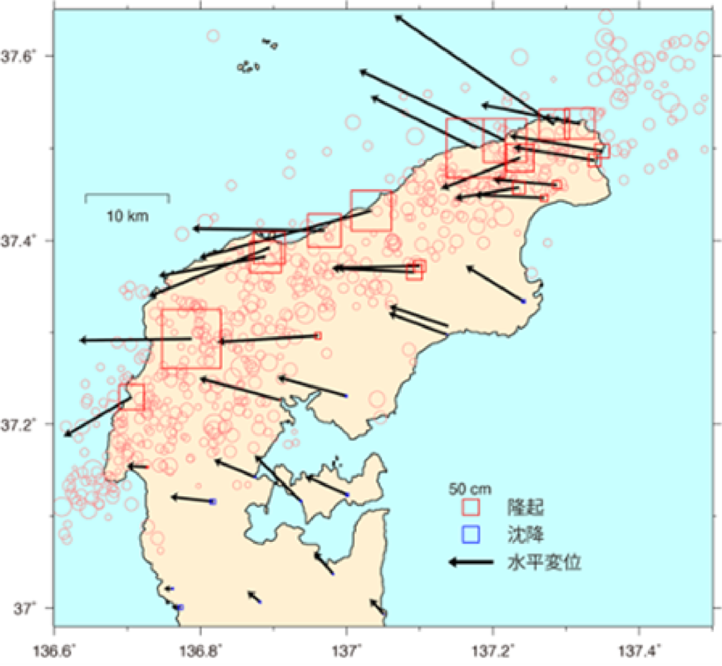
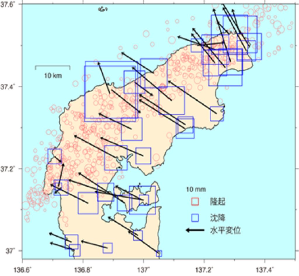
Crustal deformation at and after the occurrence of the 2024 Noto Peninsula Earthquake (magnitude 7.6) obtained through integrated GNSS analyses using data from SoftBank original reference sites, GEONET operated by the Geospatial Information Authority of Japan, and observation stations of Kyoto University and Kanazawa University. Red circles indicate the epicenter of the earthquake that occurred on January 1 (information provided by the Japan Meteorological Agency).
(Left) Coseismic crustal deformation. The difference between observations from December 22–31, 2023 and January 22–31, 2024 (for one site only, February 9–18) was defined as the coseismic deformation.
(Right) Postseismic crustal deformation over 32 days, obtained by logarithmic function fitting.
・Figure 2
Trademarks
(Left) Comparison between the estimated coseismic slip distribution and the horizontal displacement field. Black arrows indicate observed displacements, and white arrows indicate displacements predicted by the model.
(Right) Comparison between the estimated coseismic slip distribution and the vertical displacement field.
- The names and logos SoftBank and SoftBank are registered trademarks or trademarks of SoftBank Group Corp. in Japan and other countries.
- Other company names and product or service names mentioned in this press release are registered trademarks or trademarks of their respective owners.
